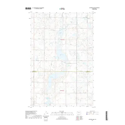
2017 Map of Lostwood Lakes
USGS Topo · Published 2017About this map
Upper Lostwood Lake and Lower Lostwood Lake dominate this prairie pothole landscape, which straddles the boundary between Burke and Mountrail counties. This region is characterized by an extensive network of ephemeral and permanent wetlands, including the uniquely named Dead Dog Slough, Merrills Slough, and Kittelson Slough. These glacial depressions are interspersed with a rigid grid of section roads like 84th Ave NW and 83rd St NW, showing the intersection of natural hydrology and human surveying. For those researching local heritage, several small burial sites are preserved here, including Nazareth Cem and Vanville Cem in the north, and Hide and Stone Cem further east. The National Hiking Trail winds through the northern sections, crossing the undulating terrain between School Section Lake and Salon Lake.
Find a feature on this map
37 named features on this map. Tap any name to fly to it.
Don’t see what you’re looking for? This feature index may not catch every label — zoom into the map to look around manually.
Map Details
Editions of this 2017 Lostwood Lakes Map
This is the sole edition of this map. No revisions or reprints were ever made.
Other maps of this area

1948 · Vanville NE
USGS Topo · 1:24,000

1950 · Vanville NE
USGS Topo · 1:24,000

1953 · Williston
USGS Topo · 1:250,000

1957 · Williston
USGS Topo · 1:250,000
1974 · Thompson Lake
USGS Topo · 1:24,000
1974 · Helde Lake
USGS Topo · 1:24,000

1974 · Lostwood Lakes
USGS Topo · 1:24,000

1978 · Westby Lake
USGS Topo · 1:24,000
1978 · Lunds Valley
USGS Topo · 1:24,000

1981 · Lostwood
USGS Topo · 1:24,000