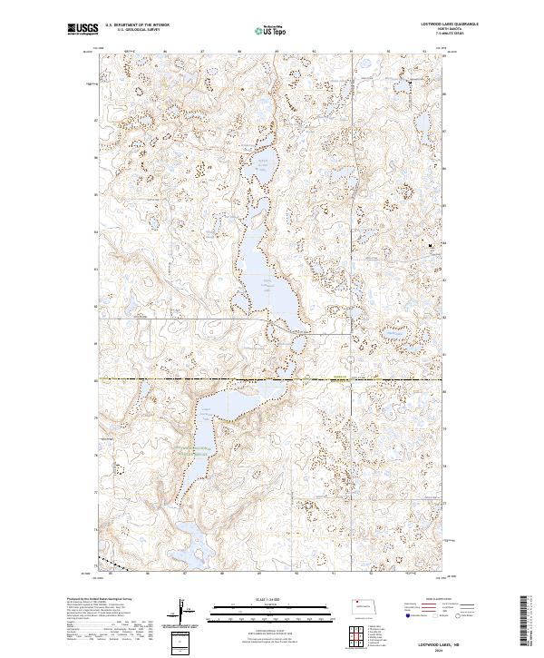
2024 Map of Lostwood Lakes
USGS Topo · Published 2024About this map
Lostwood National Wildlife Refuge dominates this section of the prairie pothole region, where a complex network of glacial lakes and sloughs defines the landscape. The geography is characterized by varying water bodies, from the expansive Upper Lostwood Lake and Lower Lostwood Lake to smaller, distinct features like Dead Dog Slough and Pauls Slough. The area's human history is marked by small rural burial sites, including the Nasareth Cem in the northeast and the Hide and Stone Cem further south. This map also tracks the transition between Burke and Mountrail Counties, showing the protected conservation lands of the Mountrail County Waterfowl Production Area. A grid of section-line roads, such as 80th St NW and 76th St NW, provides access to this waterfowl-rich environment.
Find a feature on this map
31 named features on this map. Tap any name to fly to it.
Don’t see what you’re looking for? This feature index may not catch every label — zoom into the map to look around manually.
Map Details
Editions of this 2024 Lostwood Lakes Map
This is the sole edition of this map. No revisions or reprints were ever made.
Other maps of this area

1948 · Vanville NE
USGS Topo · 1:24,000

1950 · Vanville NE
USGS Topo · 1:24,000

1953 · Williston
USGS Topo · 1:250,000

1957 · Williston
USGS Topo · 1:250,000
1974 · Thompson Lake
USGS Topo · 1:24,000
1974 · Helde Lake
USGS Topo · 1:24,000

1974 · Lostwood Lakes
USGS Topo · 1:24,000

1978 · Westby Lake
USGS Topo · 1:24,000
1978 · Lunds Valley
USGS Topo · 1:24,000

1981 · Lostwood
USGS Topo · 1:24,000