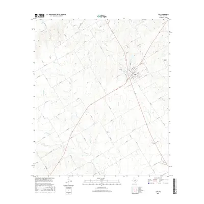
2016 Map of Lott
USGS Topo · Published 2016About this map
Lott serves as the central hub of this Falls County landscape, where the local road network converges near the Sacred Heart Cem and Clover Hill Cem. The area is defined by a dense system of seasonal drainages and creeks, including Little Deer Cr and Miller Br in the north, which feed into larger arteries like Pond Cr to the south. This terrain has long dictated the placement of rural homesteads and family cemeteries, such as the Carolina Cem and Union Cem, which sit on higher ground away from the floodplains of Live Oak Cr. Further south, the settlement of Travis marks a distinct community point near the Phillips Cem. The presence of the JCJ Farm Airport near Bell Br illustrates the modern agricultural utility of the land, while the numerous county roads like FM 431 and FM 935 trace the long-standing property lines and farm-to-market routes that have sustained this region for generations.
Find a feature on this map
93 named features on this map. Tap any name to fly to it.
Don’t see what you’re looking for? This feature index may not catch every label — zoom into the map to look around manually.
Map Details
Editions of this 2016 Lott Map
This is the sole edition of this map. No revisions or reprints were ever made.
Other maps of this area

1892 · Temple
USGS Topo · 1:125,000

1954 · Waco
USGS Topo · 1:250,000

1955 · Waco
USGS Topo · 1:250,000

1957 · Bruceville
USGS Topo · 1:24,000

1957 · Chilton
USGS Topo · 1:24,000

1957 · Marlin
USGS Topo · 1:24,000

1962 · Rosebud
USGS Topo · 1:24,000

1962 · Cedar Springs
USGS Topo · 1:24,000
1963 · Westphalia
USGS Topo · 1:24,000
1963 · Seaton
USGS Topo · 1:24,000