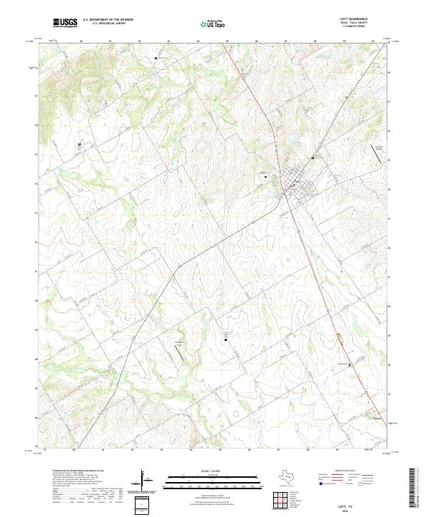
2022 Map of Lott
USGS Topo · Published 2022About this map
Lott serves as the primary hub in this central Falls County landscape, where the town's street grid, including Hackberry St and E Walnut St, stands in contrast to the surrounding agricultural terrain. The area is defined by a dense network of seasonal drainages and creeks, such as Cottonwood Cr and Cactus Br, which historically dictated the placement of homesteads and roadways. To the southeast, the small settlement of Travis marks a distinct point of habitation along the transportation corridor.
Find a feature on this map
97 named features on this map. Tap any name to fly to it.
Don’t see what you’re looking for? This feature index may not catch every label — zoom into the map to look around manually.
Map Details
Editions of this 2022 Lott Map
This is the sole edition of this map. No revisions or reprints were ever made.
Other maps of this area

1892 · Temple
USGS Topo · 1:125,000

1954 · Waco
USGS Topo · 1:250,000

1955 · Waco
USGS Topo · 1:250,000

1957 · Bruceville
USGS Topo · 1:24,000

1957 · Chilton
USGS Topo · 1:24,000

1957 · Marlin
USGS Topo · 1:24,000

1962 · Rosebud
USGS Topo · 1:24,000

1962 · Cedar Springs
USGS Topo · 1:24,000
1963 · Westphalia
USGS Topo · 1:24,000
1963 · Seaton
USGS Topo · 1:24,000