
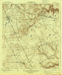
1920 Map of Louetta
USGS Topo · Published 1920About this map
Tomball and Hufsmith anchor the northwestern portion of this Harris County landscape, which is defined by a dense network of early rail lines and timber processing. The International and Great Northern and the Trinity and Brazos Valley railroads intersect this territory, supporting local industry represented by the Ross Sawmill and Puryer Sawmill. These timber operations and rail sidings like Willow Siding were central to the rural economy before the massive expansion of the Houston metropolitan area.
Find a feature on this map
31 named features on this map. Tap any name to fly to it.
Don’t see what you’re looking for? This feature index may not catch every label — zoom into the map to look around manually.
Map Details
Editions of this 1920 Louetta Map
2 editions found
Other maps of this area

1915 · Cypress
USGS Topo · 1:24,000

1916 · Rose Hill
USGS Topo · 1:24,000

1916 · Aldine
USGS Topo · 1:24,000

1916 · Louetta
USGS Topo · 1:24,000

1916 · Satsuma
USGS Topo · 1:24,000

1916 · Spring
USGS Topo · 1:24,000

1918 · Cypress
USGS Topo · 1:31,680

1919 · Aldine
USGS Topo · 1:31,680

1920 · Spring
USGS Topo · 1:31,680

1920 · Rose Hill
USGS Topo · 1:31,680