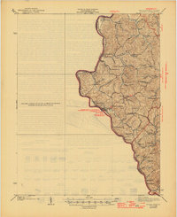
1939 Map of Louisa
USGS Topo · Published 1946About this map
The confluence of the Big Sandy River and Tug Fork centers this landscape on the West Virginia and Kentucky border. Surveyed originally in 1911 and updated in 1931, the sheet shows the twin settlements of Louisa and Fort Gay as the primary hubs of activity along the river bends. This region is characterized by a dense network of local schools serving small rural communities, including Elijah Sch and Forks of Hurricane Sch, reflecting the decentralized nature of early 20th-century education in the Appalachian foothills. The Norfolk and Western railroad tracks follow the river valley, serving as the industrial backbone for timber and coal transport through towns like Prichard and Glenhayes. Further inland, family names and local landmarks like Minnow Springs and Glassman Hill define the terrain between the numerous branches and forks of the watershed.
Find a feature on this map
74 named features on this map. Tap any name to fly to it.
Don’t see what you’re looking for? This feature index may not catch every label — zoom into the map to look around manually.
Map Details
Editions of this 1939 Louisa Map
3 editions found

Other maps of this area

1886 · Prestonsburg
USGS Topo · 1:125,000

1887 · Warfield
USGS Topo · 1:125,000

1891 · Warfield
USGS Topo · 1:125,000

1892 · Prestonsburg
USGS Topo · 1:125,000

1892 · Huntington
USGS Topo · 1:125,000

1898 · Huntington
USGS Topo · 1:125,000

1901 · Guyandot
USGS Topo · 1:62,500

1901 · Ceredo
USGS Topo · 1:62,500

1902 · Guyandot
USGS Topo · 1:62,500

1903 · Kenova
USGS Topo · 1:125,000