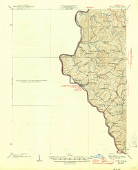
1939 Map of Louisa
USGS Topo · Published 1946About this map
The Big Sandy River and Tug Fork define the borderlands between Kentucky and West Virginia in this 1930s-era study. The region's development is centered on the confluence of these rivers at Louisa and its cross-river neighbor Fort Gay. This period shows a landscape deeply integrated with the Norfolk and Western Railway, which follows the river's path, connecting small river settlements like Prichard, Glenhayes, and Saltpetre.
Find a feature on this map
56 named features on this map. Tap any name to fly to it.
Don’t see what you’re looking for? This feature index may not catch every label — zoom into the map to look around manually.
Map Details
Editions of this 1939 Louisa Map
3 editions found

Other maps of this area

1886 · Prestonsburg
USGS Topo · 1:125,000

1887 · Warfield
USGS Topo · 1:125,000

1891 · Warfield
USGS Topo · 1:125,000

1892 · Prestonsburg
USGS Topo · 1:125,000

1892 · Huntington
USGS Topo · 1:125,000

1898 · Huntington
USGS Topo · 1:125,000

1901 · Guyandot
USGS Topo · 1:62,500

1901 · Ceredo
USGS Topo · 1:62,500

1902 · Guyandot
USGS Topo · 1:62,500

1903 · Kenova
USGS Topo · 1:125,000