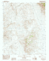
1982 Map of Louisiana Butte
USGS Topo · Published 1983About this map
The China Lake Naval Weapons Center dominates this high-desert landscape in Inyo County, where military operations intersect with ancient geological formations. Situated between the Coso Range and the Argus Range, the terrain is defined by dramatic elevation changes from the floor of Etcharren Valley to the heights of Louisiana Butte. Evidence of early and mid-20th-century land use is visible in the presence of El Canelo Mine and isolated outposts like Junction Ranch and Howard Ranch. The geography is carved by significant drainages such as Petroglyph Canyon, Renegade Canyon, and Sheep Canyon, which feed into the seasonal Carricut Lake. To the south, the flat expanse of Wild Horse Mesa provides a stark contrast to the surrounding ridges, illustrating the transition from volcanic plateaus to deep alluvial washes like Darwin Wash and Junction Wash.
Find a feature on this map
17 named features on this map. Tap any name to fly to it.
Don’t see what you’re looking for? This feature index may not catch every label — zoom into the map to look around manually.
Map Details
Editions of this 1982 Louisiana Butte Map
This is the sole edition of this map. No revisions or reprints were ever made.
Other maps of this area

1908 · Ballarat
USGS Topo · 1:250,000

1913 · Ballarat
USGS Topo · 1:250,000

1915 · Searles Lake
USGS Topo · 1:250,000

1947 · Trona
USGS Topo · 1:250,000

1948 · Trona
USGS Topo · 1:250,000

1948 · Death Valley
USGS Topo · 1:250,000

1949 · Trona
USGS Topo · 1:62,500

1950 · Trona
USGS Topo · 1:62,500

1951 · Maturango Peak
USGS Topo · 1:62,500

1951 · Coso Peak
USGS Topo · 1:62,500