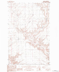
1984 Map of Lovejoy
USGS Topo · Published 1984About this map
Lovejoy sits at the heart of this North Central Montana landscape, marking a remote settlement in Phillips County during the mid-1980s. The topography is defined by the intricate drainage systems of Little Cottonwood Creek and Cottonwood Creek, which have carved deep, winding coulees through the high plains. These watercourses create a complex network of ridges and breaks that starkly contrast with the flatter upland sections of the quadrangle.
Find a feature on this map
3 named features on this map. Tap any name to fly to it.
Don’t see what you’re looking for? This feature index may not catch every label — zoom into the map to look around manually.
Map Details
Editions of this 1984 Lovejoy Map
This is the sole edition of this map. No revisions or reprints were ever made.
Other maps of this area

1920 · Avery
USGS Topo · 1:125,000

1920 · Cowan
USGS Topo · 1:125,000

1953 · Havre
USGS Topo · 1:250,000

1954 · Glasgow
USGS Topo · 1:250,000

1957 · Glasgow
USGS Topo · 1:250,000

1957 · Havre
USGS Topo · 1:250,000

1958 · Glasgow
USGS Topo · 1:250,000

1958 · Havre
USGS Topo · 1:250,000
1984 · Garland Creek
USGS Topo · 1:24,000

1984 · Austin Coulee
USGS Topo · 1:24,000