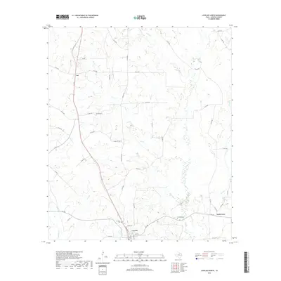
2019 Map of Lovelady North
USGS Topo · Published 2019About this map
Lovelady serves as the focal point for this section of Houston County, where a network of county roads branches out from the town center at Commerce St and Athletic Dr. The landscape is defined by the winding drainages of Hartts Cr and Gail Cr, which cut through the moderately elevated terrain. These creek systems, including Box Cr and Sookie Cr, influence the placement of rural settlements like Smith Grove and the small siding at Cut. For those researching family history in East Texas, the map identifies several local burial sites, such as Evergreen Cem near the town's edge and the more secluded Cal Wooten Cem and Rockland Cem. The layout of the roads, such as Lovelady Rd and Rockland Cem Rd, reflects a pattern of land use centered on the connection between these small communities and their agricultural surroundings.
Find a feature on this map
51 named features on this map. Tap any name to fly to it.
Don’t see what you’re looking for? This feature index may not catch every label — zoom into the map to look around manually.
Map Details
Editions of this 2019 Lovelady North Map
This is the sole edition of this map. No revisions or reprints were ever made.
Other maps of this area

1950 · Crockett
USGS Topo · 1:24,000

1951 · Crockett
USGS Topo · 1:24,000

1951 · Berea
USGS Topo · 1:24,000

1953 · Palestine
USGS Topo · 1:250,000

1957 · Palestine
USGS Topo · 1:250,000

1962 · Lovelady South
USGS Topo · 1:24,000

1962 · Glendale
USGS Topo · 1:24,000

1963 · Lovelady North
USGS Topo · 1:24,000
1963 · Fodice
USGS Topo · 1:24,000

1964 · Porter Springs
USGS Topo · 1:24,000