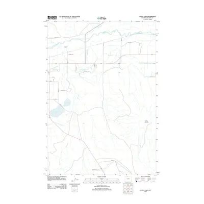
2012 Map of Lovell Lakes
USGS Topo · Published 2012About this map
The Shoshone River and an extensive network of irrigation infrastructure define this Big Horn County landscape. Engineered waterways such as the Sunlight Canal, Lovell Canal, Hunt Godfrey Canal, and Globe Canal crisscross the terrain, supporting the agricultural vitality of the region. The map highlights the significant drainage and water management systems necessary for this arid environment, including the Hooker Drain and Big Fork Canal. In the central part of the quadrangle, the Lovell Lakes provide a prominent hydrological landmark south of the river. To the east, the topography rises toward Little Sheep Mountain, while the southern reaches are marked by the erosional features of Sand Draw and the East Fork Sand Draw. This detailed survey illustrates how water engineering has fundamentally shaped the settlement and land use patterns around Lovell Lakes.
Find a feature on this map
33 named features on this map. Tap any name to fly to it.
Don’t see what you’re looking for? This feature index may not catch every label — zoom into the map to look around manually.
Map Details
Editions of this 2012 Lovell Lakes Map
This is the sole edition of this map. No revisions or reprints were ever made.
Other maps of this area

1955 · Cody
USGS Topo · 1:250,000

1958 · Cody
USGS Topo · 1:250,000

1962 · Cody
USGS Topo · 1:250,000

1964 · Kane
USGS Topo · 1:24,000

1964 · Lovell Lakes
USGS Topo · 1:24,000

1964 · Sykes Spring
USGS Topo · 1:24,000
1964 · Natural Trap Cave
USGS Topo · 1:24,000

1966 · North Emblem Reservoir
USGS Topo · 1:24,000

1966 · Cowley
USGS Topo · 1:24,000

1966 · Jack Horner Reservoir
USGS Topo · 1:24,000