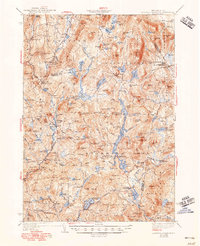
1942 Map of Lovewell Mountain
USGS Topo · Published 1948About this map
Lovewell Mountain and its surrounding granite peaks define the topography of this corner of New Hampshire during the mid-1930s revision. This survey by Hersey Munroe and R.L.McCammon details a landscape of high-elevation ponds and small, industrious settlements. Small hamlets like Mill Village and East Lempster are connected by improved dirt roads, while the Ashuelot River and its various millponds, such as Russell Millpond, suggest a legacy of water-powered industry. The presence of Advent Ch and several district schools, including School No 5 and Dole Sch, provides a clear view of the social fabric of these rural towns before modern expansion. Significant recreation landmarks like Camp Merriewood and Windsor Mtn Camps highlight the area's early 20th-century character as a summer retreat. The map also records the boundary lines between Sullivan, Cheshire, and Hillsboro counties as they intersect this highland region.
Find a feature on this map
121 named features on this map. Tap any name to fly to it.
Don’t see what you’re looking for? This feature index may not catch every label — zoom into the map to look around manually.
Map Details
Editions of this 1942 Lovewell Mountain Map
4 editions found

Other maps of this area

1898 · Monadnock
USGS Topo · 1:62,500

1898 · Keene
USGS Topo · 1:62,500

1900 · Peterboro
USGS Topo · 1:62,500

1902 · Sunapee
USGS Topo · 1:62,500

1905 · Sunapee
USGS Topo · 1:62,500

1907 · Sunapee
USGS Topo · 1:62,500

1926 · Hillsboro
USGS Topo · 1:62,500

1926 · Claremont
USGS Topo · 1:62,500

1927 · Bellows Falls
USGS Topo · 1:48,000

1928 · Mount Kearsarge
USGS Topo · 1:62,500