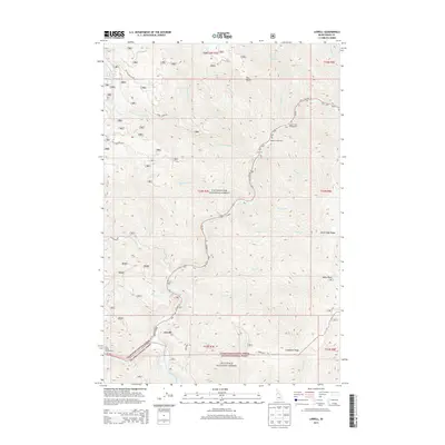
2013 Map of Lowell
USGS Topo · Published 2013About this map
Lowell sits at the dramatic confluence of the Lochsa River and the Selway River, serving as a gateway to the dense wilderness of North Central Idaho. This 2013 survey illustrates a landscape dominated by the boundaries of the Clearwater National Forest and the Nez Perce National Forest. The map documents the vital corridor of US Hwy 12, which follows the winding riverbanks past remote access points like Apgar Campground and Glade Creek Campground. Steep elevation changes are marked by distinctive landmarks such as Knife Edge Ridge and Coolwater Ridge, while numerous water sources like Icicle Spring and Lottie Cr feed into the river systems. The sparse road network, including Cabin Creek Rd and Coolwater Rd, highlights the area's character as a managed forest environment where recreational sites and natural landmarks define the human presence.
Find a feature on this map
41 named features on this map. Tap any name to fly to it.
Don’t see what you’re looking for? This feature index may not catch every label — zoom into the map to look around manually.
Map Details
Editions of this 2013 Lowell Map
This is the sole edition of this map. No revisions or reprints were ever made.
Other maps of this area

1911 · Lolo
USGS Topo · 1:250,000

1913 · Lolo
USGS Topo · 1:250,000

1924 · Weippe
USGS Topo · 1:125,000

1956 · Hamilton
USGS Topo · 1:250,000

1959 · Hamilton
USGS Topo · 1:250,000

1960 · Hamilton
USGS Topo · 1:250,000

1964 · Hamilton
USGS Topo · 1:250,000

1966 · Lowell
USGS Topo · 1:24,000
1966 · Stillman Point
USGS Topo · 1:24,000
1966 · Syringa
USGS Topo · 1:24,000