
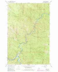
1966 Map of Lowell
USGS Topo · Published 1968About this map
The confluence of the Lochsa River and Selway River anchors this mid-century survey, marking the birth of the Middle Fk Clearwater R. The small settlement of Lowell sits at this hydrologic junction, serving as a gateway between the Clearwater National Forest to the north and the Nezperce National Forest to the south. The landscape is defined by steep drainage systems like Pete King Creek and Deadman Creek, separated by sharp features such as Knife Edge Ridge. Human activity is concentrated along the river corridors, where infrastructure includes several campgrounds like Lodge Creek Campground, a Gaging Station, and a Tramway. Higher elevations are traversed by an extensive Pack Trail network, connecting points like Rye Patch and the Chitwood Mine, indicating a history of backcountry access and resource extraction.
Find a feature on this map
35 named features on this map. Tap any name to fly to it.
Don’t see what you’re looking for? This feature index may not catch every label — zoom into the map to look around manually.
Map Details
Editions of this 1966 Lowell Map
2 editions found
Other maps of this area

1911 · Lolo
USGS Topo · 1:250,000

1913 · Lolo
USGS Topo · 1:250,000

1924 · Weippe
USGS Topo · 1:125,000

1956 · Hamilton
USGS Topo · 1:250,000

1959 · Hamilton
USGS Topo · 1:250,000

1960 · Hamilton
USGS Topo · 1:250,000

1964 · Hamilton
USGS Topo · 1:250,000
1966 · Stillman Point
USGS Topo · 1:24,000
1966 · Syringa
USGS Topo · 1:24,000
1966 · Coolwater Mtn
USGS Topo · 1:24,000