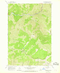
1966 Map of Coolwater Mtn
USGS Topo · Published 1968About this map
The Lochsa River carves a deep valley through the northern reaches of this Idaho landscape, serving as a primary corridor for travel and recreation in the mid-1960s. High above the water, Coolwater Mtn rises as a central peak along Coolwater Ridge, topped by a Lookout Tower that reflects the critical role of fire observation in the Clearwater National Forest. The map documents a network of footpaths and pack trails, including the Knife Edge Trail and Split Creek Trail, which connect remote high-country features such as Andys Lakes and Sheep Hill. In the river canyon, developed sites like the Major Fenn Picnic Area and Knife Edge Campground mark the intersection of wilderness and accessibility. The southern portion of the sheet transitions into the Nez Perce National Forest, where features like Remount Spring and Glover Saddle define the high ridges.
Find a feature on this map
33 named features on this map. Tap any name to fly to it.
Don’t see what you’re looking for? This feature index may not catch every label — zoom into the map to look around manually.
Map Details
Editions of this 1966 Coolwater Mtn Map
2 editions found
Other maps of this area

1911 · Lolo
USGS Topo · 1:250,000

1913 · Lolo
USGS Topo · 1:250,000

1924 · Weippe
USGS Topo · 1:125,000

1956 · Hamilton
USGS Topo · 1:250,000

1959 · Hamilton
USGS Topo · 1:250,000

1960 · Hamilton
USGS Topo · 1:250,000

1964 · Hamilton
USGS Topo · 1:250,000

1966 · Selway Falls
USGS Topo · 1:24,000

1966 · Lowell
USGS Topo · 1:24,000
1966 · Stillman Point
USGS Topo · 1:24,000