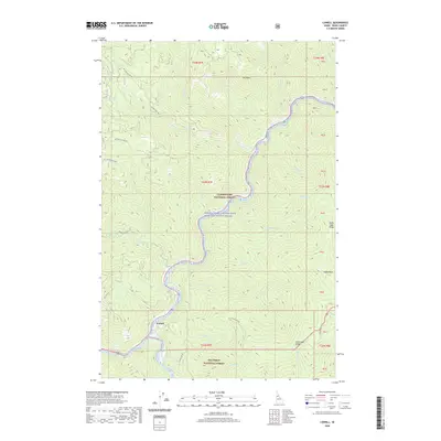
2020 Map of Lowell
USGS Topo · Published 2020About this map
Lowell sits at the significant confluence where mountain drainages meet the Middle Fork Clearwater Wild and Scenic River. This 2020 survey illustrates a landscape defined by the intersection of the Clearwater National Forest and the Nez Perce National Forest. The settlement serves as a gateway to the steep, timbered ridges of north-central Idaho, with access provided by forest routes such as Pete King Rd and Coolwater Rd. High-elevation landmarks like Coolwater Ridge, Knife Edge Ridge, and Idaho Point emphasize the dramatic vertical relief of the Clearwater basin. Numerous named creeks, including Canyon Cr and Hellgate Cr, feed into the river system, tracing the historical paths of backcountry travel and resource management within the vast national forest boundaries.
Find a feature on this map
45 named features on this map. Tap any name to fly to it.
Don’t see what you’re looking for? This feature index may not catch every label — zoom into the map to look around manually.
Map Details
Editions of this 2020 Lowell Map
This is the sole edition of this map. No revisions or reprints were ever made.
Other maps of this area

1911 · Lolo
USGS Topo · 1:250,000

1913 · Lolo
USGS Topo · 1:250,000

1924 · Weippe
USGS Topo · 1:125,000

1956 · Hamilton
USGS Topo · 1:250,000

1959 · Hamilton
USGS Topo · 1:250,000

1960 · Hamilton
USGS Topo · 1:250,000

1964 · Hamilton
USGS Topo · 1:250,000

1966 · Lowell
USGS Topo · 1:24,000
1966 · Stillman Point
USGS Topo · 1:24,000
1966 · Syringa
USGS Topo · 1:24,000