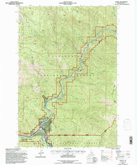
1994 Map of Lowell
USGS Topo · Published 1997About this map
The settlement of Lowell serves as the focal point of this river confluence, where the Lochsa River and the Selway River join to form the Middle Fork Clearwater River. This survey, revised in the early 1990s, documents a landscape dominated by the boundaries of the Clearwater National Forest and the Nez Perce National Forest. The presence of the Chitwood Mine on the western slopes and several significant ridge lines, including Coolwater Ridge and Knife Edge Ridge, characterizes the steep drainage basins of the area. Transport is primarily limited to the Selway River Road following the water's edge. The map captures the meeting of multiple administrative zones, including the Lochsa Ranger District and Selway Ranger District, within the steep canyon geography of central Idaho County.
Find a feature on this map
31 named features on this map. Tap any name to fly to it.
Don’t see what you’re looking for? This feature index may not catch every label — zoom into the map to look around manually.
Map Details
Editions of this 1994 Lowell Map
This is the sole edition of this map. No revisions or reprints were ever made.
Other maps of this area

1911 · Lolo
USGS Topo · 1:250,000

1913 · Lolo
USGS Topo · 1:250,000

1924 · Weippe
USGS Topo · 1:125,000

1956 · Hamilton
USGS Topo · 1:250,000

1959 · Hamilton
USGS Topo · 1:250,000

1960 · Hamilton
USGS Topo · 1:250,000

1964 · Hamilton
USGS Topo · 1:250,000

1966 · Lowell
USGS Topo · 1:24,000
1966 · Stillman Point
USGS Topo · 1:24,000
1966 · Syringa
USGS Topo · 1:24,000