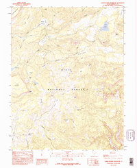
1985 Map of Lower Bowns Reservoir
USGS Topo · Published 1995About this map
Dixie National Forest defines this high-altitude landscape in Garfield County, where water management and cattle ranching shape the geography of the mid-1980s. The map centers on the Lower Bowns Reservoir, an essential highland water source supported by a substantial Dam and Spillway. This area on the eastern slopes of Boulder Mountain features a complex network of 4WD tracks connecting isolated points of interest such as Wildcat Pasture, Jorgenson Flat, and Sunflower Flat.
Find a feature on this map
50 named features on this map. Tap any name to fly to it.
Don’t see what you’re looking for? This feature index may not catch every label — zoom into the map to look around manually.
Map Details
Editions of this 1985 Lower Bowns Reservoir Map
2 editions found
Other maps of this area

1885 · Fish Lake
USGS Topo · 1:250,000

1886 · Escalante
USGS Topo · 1:250,000

1896 · Fish Lake
USGS Topo · 1:250,000

1952 · Notom 3 SW
USGS Topo · 1:24,000

1952 · Notom 3 NW
USGS Topo · 1:24,000

1952 · Notom 4 NW
USGS Topo · 1:24,000

1952 · Notom 4 SW
USGS Topo · 1:24,000

1952 · Notom 3 SE
USGS Topo · 1:24,000

1952 · Notom 3 NE
USGS Topo · 1:24,000

1952 · Grover
USGS Topo · 1:62,500