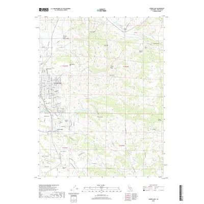
2018 Map of Lower Lake
USGS Topo · Published 2018About this map
Clearlake and Lower Lake anchor this 2018 survey, reflecting a landscape defined by significant elevation changes and the complex drainage of the Cache Creek watershed. The grid-based expansion of Clearlake contrasts sharply with the mountainous terrain to the east, where summits like Bally Peak and Quackenbush Mtn dominate the horizon. In the lower reaches, the Lower Lake Cemetery and Yuba College serve as important local landmarks for those tracing family history or institutional growth in Lake County. To the southeast, the terrain opens into the Excelsior Valley, while the north and east are marked by rugged features such as Redbank Gorge and the Al Slides. The map also captures the hydraulic network of Burns Valley and various named canyons, including Soda Canyon and Grizzly Canyon, illustrating how the community is integrated into the steep northern California topography.
Find a feature on this map
122 named features on this map. Tap any name to fly to it.
Don’t see what you’re looking for? This feature index may not catch every label — zoom into the map to look around manually.
Map Details
Editions of this 2018 Lower Lake Map
This is the sole edition of this map. No revisions or reprints were ever made.
Other maps of this area

1920 · Venado
USGS Topo · 1:62,500

1924 · Bartlett Springs
USGS Topo · 1:62,500

1942 · Bartlett Springs
USGS Topo · 1:62,500

1943 · Morgan Valley
USGS Topo · 1:62,500

1944 · Bartlett Springs
USGS Topo · 1:62,500

1944 · Wilbur Springs
USGS Topo · 1:62,500

1944 · Morgan Valley
USGS Topo · 1:62,500

1945 · Lower Lake
USGS Topo · 1:62,500

1947 · Santa Rosa
USGS Topo · 1:250,000

1949 · Santa Rosa
USGS Topo · 1:250,000