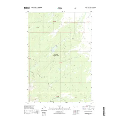
2020 Map of Lower Miner Lakes
USGS Topo · Published 2020About this map
Beaverhead National Forest defines the high-altitude landscape of this 2020 survey, where the Continental Divide National Scenic Trail winds through the southwestern corner of the quadrangle. The terrain is marked by a network of alpine water systems, including the Lower Miner Lakes and Englejard Lake, which feed the drainages of Miner Cr and Hamby Cr. Early engineering for water management is visible in the Jackson Miner Ditch, a feature that highlights the historical importance of water rights and transport in this part of Montana. Named clearings such as Gravelle Park and Berry Meadows offer insight into the local geography between timberlines. Access into this back-country is provided by primitive routes like Miner Lake Rd and Englejard Rd, which support both recreational use and resource management within the forest boundaries.
Find a feature on this map
22 named features on this map. Tap any name to fly to it.
Don’t see what you’re looking for? This feature index may not catch every label — zoom into the map to look around manually.
Map Details
Editions of this 2020 Lower Miner Lakes Map
This is the sole edition of this map. No revisions or reprints were ever made.
Other maps of this area

1955 · Dillon
USGS Topo · 1:250,000

1956 · Goldstone Mtn
USGS Topo · 1:62,500

1957 · Dillon
USGS Topo · 1:250,000

1958 · Dillon
USGS Topo · 1:250,000

1962 · Dillon
USGS Topo · 1:250,000

1965 · Dillon
USGS Topo · 1:250,000

1966 · Miner Lake
USGS Topo · 1:24,000

1966 · Jumbo Mountain
USGS Topo · 1:24,000
1966 · Ajax Ranch
USGS Topo · 1:24,000
1966 · Homer Youngs Peak
USGS Topo · 1:24,000