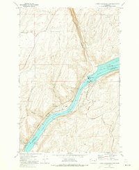
1970 Map of Lower Monumental Dam
USGS Topo · Published 1973About this map
Lower Monumental Dam stands as the central engineering feat along the Snake River in this 1970 study, which captures the industrial and agricultural landscape of the Franklin and Walla Walla county border. The completion of the dam created Lake Sacajawea, a significant body of water that reshaped the local geography. Small railroad-oriented settlements like Farrington and Windust are documented along the northern bank, while the Burlington Northern and Union Pacific lines trace the river's path, emphasizing the area's role as a vital transportation corridor. The map details a landscape carved by numerous coulees, including Devils Canyon and Bouvey Canyon, which cut through the high plateau. Infrastructure such as the Lower Monumental Airport, a Substation, and a Grain Elevator illustrate the intersection of modern energy production and traditional dryland farming at the dawn of the 1970s.
Find a feature on this map
29 named features on this map. Tap any name to fly to it.
Don’t see what you’re looking for? This feature index may not catch every label — zoom into the map to look around manually.
Map Details
Editions of this 1970 Lower Monumental Dam Map
This is the sole edition of this map. No revisions or reprints were ever made.
Other maps of this area

1915 · Wallulah
USGS Topo · 1:96,000

1916 · Connell
USGS Topo · 1:125,000

1918 · Connell
USGS Topo · 1:125,000

1918 · Wallula
USGS Topo · 1:125,000

1919 · Walla Walla
USGS Topo · 1:125,000

1921 · Walla Walla
USGS Topo · 1:125,000

1948 · Ayer
USGS Topo · 1:62,500

1950 · Haas
USGS Topo · 1:62,500

1953 · Walla Walla
USGS Topo · 1:250,000

1958 · Walla Walla
USGS Topo · 1:250,000