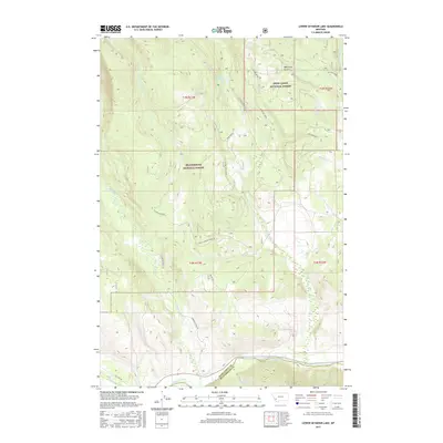
2017 Map of Lower Seymour Lake
USGS Topo · Published 2017About this map
Lower Seymour Lake sits at the heart of this high-elevation landscape, where the headwaters of numerous creeks converge near the boundary of Deer Lodge National Forest and Beaverhead National Forest. This 2017 survey details a region defined by its complex drainage network, featuring Seymour Creek and La Marche Creek as they descend toward the Big Hole River. A notable piece of water management infrastructure, the Bacon Ditch, cuts across the terrain, illustrating the historical and ongoing efforts to divert water through these mountains. The map also traces established access routes like Seymour Creek Road and LaMarche Creek Road, which provide the primary entry points into these timbered lands. From the seasonal flows of Minnie Creek to the narrow passage of Bear Trap Gulch, the sheet offers a precise look at the hydrology of the Continental Divide's eastern slopes.
Find a feature on this map
34 named features on this map. Tap any name to fly to it.
Don’t see what you’re looking for? This feature index may not catch every label — zoom into the map to look around manually.
Map Details
Editions of this 2017 Lower Seymour Lake Map
This is the sole edition of this map. No revisions or reprints were ever made.
Other maps of this area

1908 · Philipsburg
USGS Topo · 1:125,000

1947 · Butte
USGS Topo · 1:250,000

1955 · Dillon
USGS Topo · 1:250,000

1957 · Dillon
USGS Topo · 1:250,000

1958 · Butte
USGS Topo · 1:250,000

1958 · Dillon
USGS Topo · 1:250,000

1960 · Butte
USGS Topo · 1:250,000

1962 · Butte
USGS Topo · 1:250,000

1962 · Dillon
USGS Topo · 1:250,000

1962 · Lincoln Gulch
USGS Topo · 1:24,000