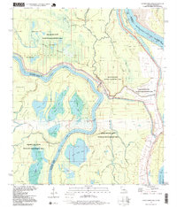
1996 Map of Lower Sunk Lake
USGS Topo · Published 1999About this map
The confluence of the Red River and the Mississippi River creates a dynamic watery landscape across the borders of Louisiana and Mississippi. This environment is characterized by intricate drainage systems and abandoned river channels, including the Grand Cutoff Bayou and Red River Bay. The complex geography of the Dismal Swamp and Devils Swamp dominates the central terrain, highlighting how the natural movement of these major rivers has shaped the regional topography.
Find a feature on this map
51 named features on this map. Tap any name to fly to it.
Don’t see what you’re looking for? This feature index may not catch every label — zoom into the map to look around manually.
Map Details
Editions of this 1996 Lower Sunk Lake Map
This is the sole edition of this map. No revisions or reprints were ever made.
Other maps of this area

1935 · Tooleys
USGS Topo · 1:62,500

1939 · Artonish
USGS Topo · 1:62,500

1939 · Deer Park
USGS Topo · 1:62,500

1941 · Voorhies
USGS Topo · 1:62,500

1941 · Tooleys
USGS Topo · 1:62,500

1953 · Natchez
USGS Topo · 1:250,000

1954 · Artonish
USGS Topo · 1:62,500

1955 · Artonish
USGS Topo · 1:62,500

1956 · Natchez
USGS Topo · 1:250,000

1958 · Artonish
USGS Topo · 1:62,500