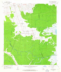
1962 Map of Lower Vacherie
USGS Topo · Published 1963About this map
Sugar cane cultivation and swamp drainage define the landscape of St. James Parish on the eve of the mid-century's industrial expansion. The settlement of Lower Vacherie serves as a central hub, surrounded by long-established agricultural estates such as Southdown Plantation, Webre Steib Plantation, and Golden Star Plantation. These landholdings follow the traditional French long-lot system, stretching back from the higher ground near the Mississippi River toward the low-lying backswamps. The northern portion of the map is dominated by the Texas and Pacific railroad line, which facilitated the movement of goods through the region.
Find a feature on this map
27 named features on this map. Tap any name to fly to it.
Don’t see what you’re looking for? This feature index may not catch every label — zoom into the map to look around manually.
Map Details
Editions of this 1962 Lower Vacherie Map
4 editions found
Other maps of this area

1892 · Lac Des Allemands
USGS Topo · 1:62,500

1892 · Mount Airy
USGS Topo · 1:62,500

1892 · Donaldsonville
USGS Topo · 1:62,500

1892 · Thibodaux
USGS Topo · 1:62,500

1932 · Lac Des Allemands NW
USGS Topo · 1:31,680

1932 · Lac Des Allemands SE
USGS Topo · 1:31,680

1932 · Lac Des Allemands SW
USGS Topo · 1:31,680

1932 · Thibodaux NE
USGS Topo · 1:31,680

1932 · Lac Des Allemands NE
USGS Topo · 1:31,680

1932 · Thibodaux SE
USGS Topo · 1:31,680
Featured Places
- Golden Star Plantation, LA
- North Vacherie, LA
- Southdown Plantation, LA
- Armant, LA
- Webre Steib Plantation, LA