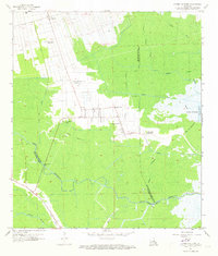
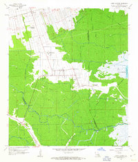
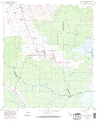
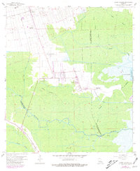
1962 Map of Lower Vacherie
USGS Topo · Published 1973About this map
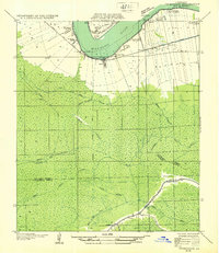
Southdown Plantation and Webre Steib Plantation mark the agricultural landscape of St. James Parish during the early 1960s, showing the enduring structure of the Mississippi River sugar belt. The settlement patterns follow a distinct linear arrangement along the elevated natural levees, with Lower Vacherie serving as a central hub. This community is anchored by the Lady of Mercy Ch and Miles Memorial Park, while the surrounding wetlands are crisscrossed by a complex network of waterways including the Dredge Boat Canal and the meandering Bayou Chevreuil.
Find a feature on this map
35 named features on this map. Tap any name to fly to it.
Don’t see what you’re looking for? This feature index may not catch every label — zoom into the map to look around manually.
Map Details
Editions of this 1962 Lower Vacherie Map
4 editions found
Other maps of this area

1892 · Lac Des Allemands
USGS Topo · 1:62,500

1892 · Mount Airy
USGS Topo · 1:62,500

1892 · Donaldsonville
USGS Topo · 1:62,500

1892 · Thibodaux
USGS Topo · 1:62,500

1932 · Lac Des Allemands NW
USGS Topo · 1:31,680

1932 · Lac Des Allemands SE
USGS Topo · 1:31,680

1932 · Lac Des Allemands SW
USGS Topo · 1:31,680
1932 · Thibodaux NE
USGS Topo · 1:31,680
1932 · Lac Des Allemands NE
USGS Topo · 1:31,680

1932 · Thibodaux SE
USGS Topo · 1:31,680
Featured Places
- Golden Star Plantation, LA
- North Vacherie, LA
- Southdown Plantation, LA
- Armant, LA
- Webre Steib Plantation, LA