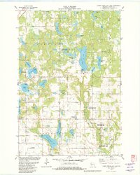
1982 Map of Lower Vermillion Lake
USGS Topo · Published 1982About this map
Upper Vermillion Lake and its downstream counterpart Lower Vermillion Lake dominate this Barron County landscape, which transitioned from a glaciated wilderness to a recreational and agricultural hub by the early 1980s. The region is defined by a dense concentration of kettle lakes, including uniquely named features like Big Dummy Lake, Pea Viner Lake, and Lake Thirty. The Chicago and North Western line cuts through the northwestern corner, providing a link to larger markets that historically supported local industry. Cultural and community centers are visible in the form of the Section Ten Ch and an unnamed Cem, alongside recreational sites like Rainbow Ranch Camp and Grant County Park. Significant portions of the watershed are managed for conservation, notably the Grassy Lake State Public Fishery Area and several tracts along the Yellow River.
Find a feature on this map
48 named features on this map. Tap any name to fly to it.
Don’t see what you’re looking for? This feature index may not catch every label — zoom into the map to look around manually.
Map Details
Editions of this 1982 Lower Vermillion Lake Map
This is the sole edition of this map. No revisions or reprints were ever made.
Other maps of this area

1950 · Turtle Lake
USGS Topo · 1:62,500

1951 · Cumberland
USGS Topo · 1:48,000

1951 · Shell Lake
USGS Topo · 1:48,000

1951 · Barron
USGS Topo · 1:62,500

1952 · Turtle Lake
USGS Topo · 1:62,500

1953 · Rice Lake
USGS Topo · 1:250,000

1953 · Stillwater
USGS Topo · 1:250,000

1955 · Stillwater
USGS Topo · 1:250,000

1956 · Cumberland
USGS Topo · 1:62,500

1958 · Stillwater
USGS Topo · 1:250,000