
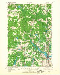
1956 Map of Cumberland
USGS Topo · Published 1957About this map
Cumberland stands as a hub of activity in this 1950s landscape, positioned near the Fish Hatchery and St Anthony Ch at the edge of the lake-studded terrain. The region is defined by a dense network of rural infrastructure, where small community centers like Timberland and Loraine are anchored by local institutions such as the Timberland Ch and Roosevelt Sch. The distribution of dozens of schools, including the Granite Lake Sch and South Dewey Sch, suggests a decentralized but well-populated rural society before the era of widespread school consolidation. The landscape is punctuated by numerous named bodies of water like Peacock Lake and Largon Lake, alongside distinctive geological features like Shay Mound. This survey captures the county lines of Barron, Polk, Burnett, and Washburn, documenting a period when small-scale country churches and schoolhouses still served as the primary social landmarks for local families.
Find a feature on this map
93 named features on this map. Tap any name to fly to it.
Don’t see what you’re looking for? This feature index may not catch every label — zoom into the map to look around manually.
Map Details
Editions of this 1956 Cumberland Map
2 editions found
Other maps of this area

1948 · Spooner
USGS Topo · 1:48,000

1949 · Hertel
USGS Topo · 1:48,000

1949 · Spooner
USGS Topo · 1:48,000

1950 · Webster
USGS Topo · 1:48,000

1950 · Balsam Lake
USGS Topo · 1:62,500

1950 · Turtle Lake
USGS Topo · 1:62,500

1951 · Cumberland
USGS Topo · 1:48,000

1951 · Frederic
USGS Topo · 1:48,000

1951 · Shell Lake
USGS Topo · 1:48,000

1951 · Barron
USGS Topo · 1:62,500