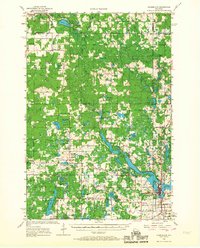
1956 Map of Cumberland
USGS Topo · Published 1967About this map
Cumberland anchors this mid-century landscape where the glacial topography of northwestern Wisconsin creates a dense network of water bodies and wetlands. The city sits positioned between Beaverdam Lake and the Hay River, serving as a hub for the surrounding rural townships of Maple Plain and Crystal Lake. The map captures a detailed distribution of local civic life, from the Maple Plain Fish Hatchery to numerous country schools like Bergman Sch and McKinley Sch.
Find a feature on this map
94 named features on this map. Tap any name to fly to it.
Don’t see what you’re looking for? This feature index may not catch every label — zoom into the map to look around manually.
Map Details
Editions of this 1956 Cumberland Map
2 editions found

Other maps of this area

1948 · Spooner
USGS Topo · 1:48,000

1949 · Hertel
USGS Topo · 1:48,000

1949 · Spooner
USGS Topo · 1:48,000

1950 · Webster
USGS Topo · 1:48,000

1950 · Balsam Lake
USGS Topo · 1:62,500

1950 · Turtle Lake
USGS Topo · 1:62,500

1951 · Cumberland
USGS Topo · 1:48,000

1951 · Frederic
USGS Topo · 1:48,000

1951 · Shell Lake
USGS Topo · 1:48,000

1951 · Barron
USGS Topo · 1:62,500