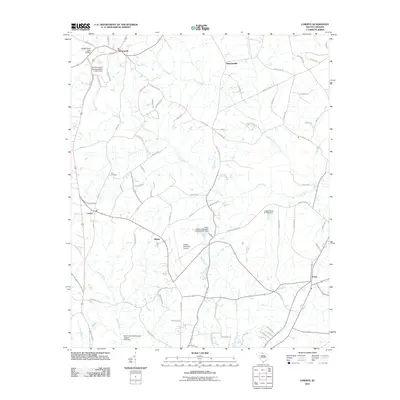
2011 Map of Lowrys
USGS Topo · Published 2011About this map
McConnells and Brattonsville anchor the northern landscape of this South Carolina region, where the rural character is defined by a network of creeks and small-scale dams. The terrain is drained by the South Fork Fishing Creek and the Sandy River, with numerous unnamed dams and labeled structures like Aycock Pond Dam D-3667 creating local water catchments. Centrally located, the Chester Municipal Airport marks a modern utility point amidst a grid of local roads and family-named routes such as Davis Lever Rd and James F Wherry Rd. The southern reach includes the small settlements of Dinber and Lewis, while the Zion Cemetery provides a focal point for genealogical interest. This map captures the area's transition between traditional agrarian settlements and specialized local infrastructure like the many South Carolina noname dams dotting the drainage basins of Rocky Creek.
Find a feature on this map
81 named features on this map. Tap any name to fly to it.
Don’t see what you’re looking for? This feature index may not catch every label — zoom into the map to look around manually.
Map Details
Editions of this 2011 Lowrys Map
This is the sole edition of this map. No revisions or reprints were ever made.
Other maps of this area

1907 · Sharon
USGS Topo · 1:62,500

1941 · Spartanburg
USGS Topo · 1:250,000

1949 · Rock Hill
USGS Topo · 1:62,500

1953 · Spartanburg
USGS Topo · 1:250,000

1960 · Spartanburg
USGS Topo · 1:250,000

1963 · Spartanburg
USGS Topo · 1:250,000

1964 · Spartanburg
USGS Topo · 1:250,000
1969 · Richburg
USGS Topo · 1:24,000

1969 · Baton Rouge
USGS Topo · 1:24,000
1969 · Chester
USGS Topo · 1:24,000