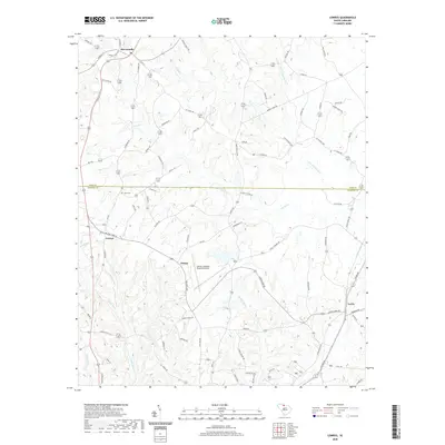
2020 Map of Lowrys
USGS Topo · Published 2020About this map
McConnells and Lowrys serve as the primary hubs in this Piedmont landscape where York and Chester counties meet. The area is defined by its dendritic drainage patterns, with the Sandy River and S Fork Fishing Cr carving through the terrain alongside numerous named tributaries like Love Cr and Conrad Cr. Rural development is concentrated along historic corridors such as Old York Rd, which connects the older town centers with newer residential clusters like Louden Hts and Farmwood Ests. The presence of the Chester Catawba Regional Airport near Dinber represents a significant modern infrastructure footprint amidst the traditional agricultural and residential landscape. Genealogists and local historians can use the map to locate smaller communities like Lewis and quiet landmarks such as Zion Cem, providing a detailed view of the region's 21st-century spatial organization.
Find a feature on this map
81 named features on this map. Tap any name to fly to it.
Don’t see what you’re looking for? This feature index may not catch every label — zoom into the map to look around manually.
Map Details
Editions of this 2020 Lowrys Map
This is the sole edition of this map. No revisions or reprints were ever made.
Other maps of this area

1907 · Sharon
USGS Topo · 1:62,500

1941 · Spartanburg
USGS Topo · 1:250,000

1949 · Rock Hill
USGS Topo · 1:62,500

1953 · Spartanburg
USGS Topo · 1:250,000

1960 · Spartanburg
USGS Topo · 1:250,000

1963 · Spartanburg
USGS Topo · 1:250,000

1964 · Spartanburg
USGS Topo · 1:250,000
1969 · Richburg
USGS Topo · 1:24,000

1969 · Baton Rouge
USGS Topo · 1:24,000
1969 · Chester
USGS Topo · 1:24,000