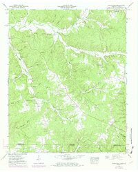
1949 Map of Lowryville
USGS Topo · Published 1973About this map
Lowryville and the surrounding borderlands of Tennessee and Alabama define this mid-century topographic record, which documents a landscape deeply etched by the drainage of Horse Creek and its many winding tributaries. The settlement pattern here is dictated by the rugged creek hollows, with small communities like Walnut Grove and Sand Hill serving as anchors for rural life. Genealogists and historians will find a wealth of specific local landmarks, from Pollards Mill on the waters of Holland Creek to a dense network of family and community burial grounds, including Stricklin Cem, Fielder Cem, and the Saint Hope Cem.
Find a feature on this map
50 named features on this map. Tap any name to fly to it.
Don’t see what you’re looking for? This feature index may not catch every label — zoom into the map to look around manually.
Map Details
Editions of this 1949 Lowryville Map
2 editions found
Other maps of this area

1905 · Waynesboro
USGS Topo · 1:125,000

1911 · Iuka
USGS Topo · 1:48,000

1914 · Iuka
USGS Topo · 1:62,500

1924 · Gravelly Springs
USGS Topo · 1:48,000

1926 · Gravelly Springs
USGS Topo · 1:62,500

1935 · Wright
USGS Topo · 1:24,000

1936 · Savannah
USGS Topo · 1:24,000

1936 · Wolf Pit Ridge
USGS Topo · 1:24,000

1936 · Waterloo
USGS Topo · 1:24,000

1936 · Shaws
USGS Topo · 1:24,000