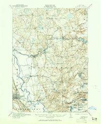
1911 Map of Lowville
USGS Topo · Published 1965About this map
The Beaver River and Lowville and Beaver River railroad define the industrial and transit corridor of this Lewis County region during the early twentieth century. Centered on the village of Lowville, the landscape transitions from the river valley into the upland terrain of the Crystal Hills and the edge of the Adirondacks. The map documents a dense network of local education, featuring numerous named rural schoolhouses such as the Texas Road School, Wisner School, and Summit School that served the dispersed farming and logging communities. Water power is a central theme, evidenced by the Power Plant at Elmer Falls and the industrial operations at Petries Mill. Small settlements like Croghan, Beaver Falls, and New Bremen appear as established hubs, while the survey captures the complex hydrology of the Independence River and the high concentration of small lakes and ponds in the eastern territory.
Find a feature on this map
85 named features on this map. Tap any name to fly to it.
Don’t see what you’re looking for? This feature index may not catch every label — zoom into the map to look around manually.
Map Details
Editions of this 1911 Lowville Map
2 editions found
Other maps of this area

1902 · Carthage
USGS Topo · 1:62,500

1904 · Carthage
USGS Topo · 1:62,500

1905 · Port Leyden
USGS Topo · 1:62,500

1906 · Highmarket
USGS Topo · 1:62,500

1907 · Port Leyden
USGS Topo · 1:62,500

1911 · Antwerp
USGS Topo · 1:62,500

1911 · Lowville
USGS Topo · 1:62,500

1912 · Number Four
USGS Topo · 1:62,500

1912 · Mc Keever
USGS Topo · 1:62,500

1913 · Lowville
USGS Topo · 1:62,500