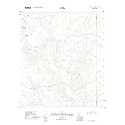
2019 Map of Lozier Canyon North
USGS Topo · Published 2019About this map
Malvado sits at the edge of a complex network of draws and canyons where the high desert plateau begins its descent toward the Rio Grande basin. The landscape is defined by the massive drainage of Lozier Canyon, which serves as the central artery for numerous tributaries including Thurston Canyon, Meyers Canyon, and Sevenmile Canyon. This map reveals a region largely defined by its drainage patterns rather than dense settlement, though a sparse network of roads provides access to this isolated portion of the Trans-Pecos. Notable travel routes such as Big Lozier Rd, White Rd, and Cinco De Mayo Rd trace the high ground between deep cuts like Jones Draw and Palma Canyon. The eastern boundary of the map follows the line between Terrell and Val Verde Counties, cutting through Pumpville Canyon as the terrain shifts toward the lower canyons.
Find a feature on this map
20 named features on this map. Tap any name to fly to it.
Don’t see what you’re looking for? This feature index may not catch every label — zoom into the map to look around manually.
Map Details
Editions of this 2019 Lozier Canyon North Map
This is the sole edition of this map. No revisions or reprints were ever made.
Other maps of this area

1943 · Malvado
USGS Topo · 1:62,500

1943 · Langtry
USGS Topo · 1:62,500

1944 · Malvado
USGS Topo · 1:62,500

1954 · Sonora
USGS Topo · 1:250,000

1958 · Sonora
USGS Topo · 1:250,000

1958 · Del Rio
USGS Topo · 1:250,000

1964 · Del Rio
USGS Topo · 1:250,000
1979 · Cook Creek North
USGS Topo · 1:24,000
1979 · Lozier Canyon North
USGS Topo · 1:24,000
1979 · Cook Creek South
USGS Topo · 1:24,000