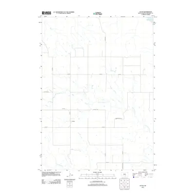
2012 Map of Lucas
USGS Topo · Published 2012About this map
Lucas serves as the central settlement point in this Gregory County landscape, situated amidst a network of township highways and prairie drainages. The area is defined by the branching paths of N Fork Whetstone Cr and S Fork Whetstone Cr, which carve through the plains toward the northeastern corner where the waters of Lake Francis Case are visible. The grid of rural roads, including Lucas Twp Hwy and Scissors Twp Hwy, reflects a highly organized agricultural layout typical of the region. Local history is anchored at the Lucas Cem, located northwest of the town center. This survey provides a precise view of the rural infrastructure and natural hydrology, from the northern flow of Rush Cr to the southern reaches of Turgeon Twp Hwy near the quadrangle boundary.
Find a feature on this map
18 named features on this map. Tap any name to fly to it.
Don’t see what you’re looking for? This feature index may not catch every label — zoom into the map to look around manually.
Map Details
Editions of this 2012 Lucas Map
This is the sole edition of this map. No revisions or reprints were ever made.
Other maps of this area

1955 · Mitchell
USGS Topo · 1:250,000

1959 · Mitchell
USGS Topo · 1:250,000

1964 · Herrick NW
USGS Topo · 1:24,000

1964 · Herrick NE
USGS Topo · 1:24,000
1964 · Burke
USGS Topo · 1:24,000

1971 · Lucas NW
USGS Topo · 1:24,000

1971 · Academy
USGS Topo · 1:24,000

1971 · Lucas
USGS Topo · 1:24,000

1971 · Dixon SE
USGS Topo · 1:24,000

1971 · Dixon NE
USGS Topo · 1:24,000