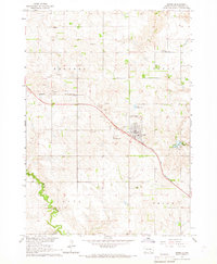
1964 Map of Burke
USGS Topo · Published 1967About this map
The town of Burke serves as the central hub of this Gregory County landscape, defined by the diagonal path of the Chicago and North Western railroad and the adjacent Burke Municipal Airport. This mid-century survey reveals a structured rural community divided into townships like Rhoades, Burke, and Jones. Small rural education sites such as Rembrandt Sch and School No 1 appear alongside several local burial grounds, including Graceland Cem and the County Home Cem. To the southeast, the terrain softens around Lake Burke and its Picnic Area, while the winding course of Ponca Creek carves through the southwestern corner. Numerous Sandpits and Gravel Pits scattered across the plains point to the local importance of aggregate mining for regional infrastructure during the 1960s.
Find a feature on this map
23 named features on this map. Tap any name to fly to it.
Don’t see what you’re looking for? This feature index may not catch every label — zoom into the map to look around manually.
Map Details
Editions of this 1964 Burke Map
This is the sole edition of this map. No revisions or reprints were ever made.
Other maps of this area

1955 · Mitchell
USGS Topo · 1:250,000

1959 · Mitchell
USGS Topo · 1:250,000

1964 · Gregory SE
USGS Topo · 1:24,000

1964 · Herrick NW
USGS Topo · 1:24,000

1964 · Gregory
USGS Topo · 1:24,000
1964 · Herrick
USGS Topo · 1:24,000
1964 · Carlock
USGS Topo · 1:24,000

1971 · Dixon SW
USGS Topo · 1:24,000

1971 · Lucas
USGS Topo · 1:24,000

1971 · Dixon SE
USGS Topo · 1:24,000