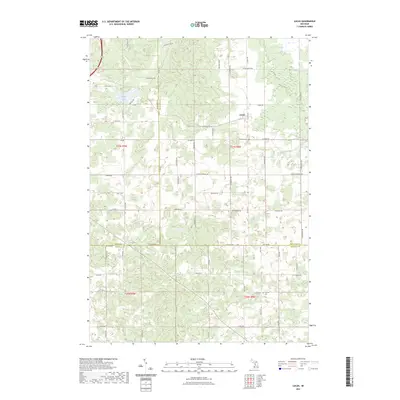
2023 Map of Lucas
USGS Topo · Published 2023About this map
The settlement of Lucas serves as a central anchor in this rural landscape where Missaukee, Wexford, and Osceola counties meet. Modern survey data reveals a countryside shaped by a regular grid of section roads, many of which carry local family names such as Meyering Rd, Hibma Rd, and S Boss Cher Rd. The area is notably defined by its many small water bodies and wetlands, including Berry Lake in the northwest and Marks Creek flowing through the eastern reaches. Local heritage is preserved at Richland Cem near the town site and Hillside Cem to the south. The presence of Evart Trail Rd suggests the historical importance of regional travel routes connecting these agricultural communities. This detailed look at the township boundaries of T21N R9W and T21N R8W provides a precise record of the parcel divisions and natural drainage patterns that have dictated local land use for generations.
Find a feature on this map
51 named features on this map. Tap any name to fly to it.
Don’t see what you’re looking for? This feature index may not catch every label — zoom into the map to look around manually.
Map Details
Editions of this 2023 Lucas Map
This is the sole edition of this map. No revisions or reprints were ever made.
Other maps of this area

1954 · Traverse City
USGS Topo · 1:250,000

1956 · Cadillac North
USGS Topo · 1:62,500

1956 · Lake City
USGS Topo · 1:62,500

1957 · Cadillac South
USGS Topo · 1:62,500

1957 · Marion
USGS Topo · 1:62,500

1958 · Traverse City
USGS Topo · 1:250,000
1983 · Dighton
USGS Topo · 1:25,000

1983 · Cadillac
USGS Topo · 1:100,000
1983 · Le Roy
USGS Topo · 1:25,000

1983 · Lake City
USGS Topo · 1:25,000