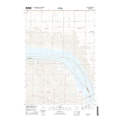
2015 Map of Lucas NW
USGS Topo · Published 2015About this map
The Missouri River carves a deep valley through this portion of South Dakota, where the expansive waters of Lake Francis Case dominate the southern landscape. The terrain transitions from the upland plains of Platte Colony in the northeast down toward the rugged bluffs overlooking the water. This 2015 survey shows the critical transport corridor provided by the Platte-Winner Bridge, which connects the high ground across the river valley. Inland from the river, the landscape is defined by the agricultural grid of section lines and rural routes like Farmers Rd and 269th St. Small tributary drainages such as Snake Cr cut through the northern reaches, while the small settlement of Red Rock sits perched on the western slopes above the reservoir, illustrating the area's sparse but deliberate pattern of occupation along the Missouri's modified course.
Find a feature on this map
14 named features on this map. Tap any name to fly to it.
Don’t see what you’re looking for? This feature index may not catch every label — zoom into the map to look around manually.
Map Details
Editions of this 2015 Lucas NW Map
This is the sole edition of this map. No revisions or reprints were ever made.
Other maps of this area

1940 · Iona
USGS Topo · 1:62,500

1944 · Iona
USGS Topo · 1:62,500

1955 · Mitchell
USGS Topo · 1:250,000

1959 · Mitchell
USGS Topo · 1:250,000

1971 · Lucas NW
USGS Topo · 1:24,000

1971 · Academy
USGS Topo · 1:24,000

1971 · Lucas
USGS Topo · 1:24,000

1971 · Dixon SE
USGS Topo · 1:24,000

1971 · Dixon NE
USGS Topo · 1:24,000

1971 · Lucas SE
USGS Topo · 1:24,000
Featured Places
- America Township, SD
- La Roche Township, SD
- Eagle Township, SD
- Platte Hutterite Colony, SD
- Charles Mix County, SD