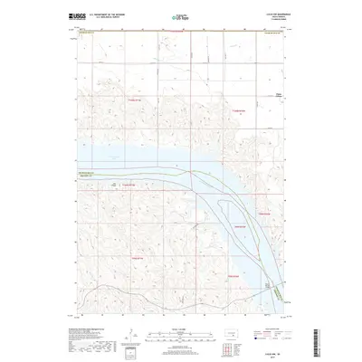
2017 Map of Lucas NW
USGS Topo · Published 2017About this map
The Missouri River corridor defines the landscape of this region, where the massive waters of Lake Francis Case stretch across the center of the sheet. On the northern plateau, Platte Colony stands near the boundary of Charles Mix County, set against a geometric grid of rural routes like Farmers Rd and 350th Ave. This era of the river's history is marked by the presence of the Platte-Winner Bridge, a vital connection spanning the water between Charles Mix and Gregory County. The terrain is characterized by the transition from flat upland fields to the deep, complex drainage systems of Snake Cr and Rush Cr, which carve into the bluffs overlooking the reservoir. Elevation points such as Red Rock provide distinct landmarks among the winding contours of the river valley.
Find a feature on this map
23 named features on this map. Tap any name to fly to it.
Don’t see what you’re looking for? This feature index may not catch every label — zoom into the map to look around manually.
Map Details
Editions of this 2017 Lucas NW Map
This is the sole edition of this map. No revisions or reprints were ever made.
Other maps of this area

1940 · Iona
USGS Topo · 1:62,500

1944 · Iona
USGS Topo · 1:62,500

1955 · Mitchell
USGS Topo · 1:250,000

1959 · Mitchell
USGS Topo · 1:250,000

1971 · Lucas NW
USGS Topo · 1:24,000

1971 · Academy
USGS Topo · 1:24,000

1971 · Lucas
USGS Topo · 1:24,000

1971 · Dixon SE
USGS Topo · 1:24,000

1971 · Dixon NE
USGS Topo · 1:24,000

1971 · Lucas SE
USGS Topo · 1:24,000
Featured Places
- America Township, SD
- La Roche Township, SD
- Eagle Township, SD
- Platte Hutterite Colony, SD
- Charles Mix County, SD