
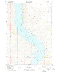
1971 Map of Lucas NW
USGS Topo · Published 1974About this map
Lake Francis Case dominates this landscape along the Missouri River trench, where the 1970s topography shows the impact of the Pick-Sloan Plan on the South Dakota prairie. The map captures the dividing line between Charles Mix, Brule, and Gregory counties, with the Platte Winner Bridge providing a critical connection across the wide waters of the reservoir. To the northeast, the communal settlement of Platte Colony sits above the breaks of the river valley, illustrating the specific social and agricultural patterns of the region. The inclusion of an indefinite boundary and reservation boundary reflects the complex land status common to this reach of the Missouri River. Smaller features like a Flowing Well and Picnic Areas along the shore point to the local water table and the recreational development that followed the damming of the river.
Find a feature on this map
12 named features on this map. Tap any name to fly to it.
Don’t see what you’re looking for? This feature index may not catch every label — zoom into the map to look around manually.
Map Details
Editions of this 1971 Lucas NW Map
This is the sole edition of this map. No revisions or reprints were ever made.
Other maps of this area

1940 · Iona
USGS Topo · 1:62,500

1944 · Iona
USGS Topo · 1:62,500

1955 · Mitchell
USGS Topo · 1:250,000

1959 · Mitchell
USGS Topo · 1:250,000

1971 · Academy
USGS Topo · 1:24,000

1971 · Lucas
USGS Topo · 1:24,000

1971 · Dixon SE
USGS Topo · 1:24,000

1971 · Dixon NE
USGS Topo · 1:24,000

1971 · Lucas SE
USGS Topo · 1:24,000
1974 · Bond Bottom
USGS Topo · 1:24,000
Featured Places
- America Township, SD
- Eagle Township, SD
- Platte Hutterite Colony, SD
- La Roche Township, SD
- Charles Mix County, SD