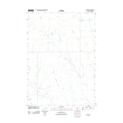
2012 Map of Lucerne
USGS Topo · Published 2012About this map
Lucerne sits in a high plains landscape dominated by the winding drainage of Buzzard Cr, which snakes through the central and eastern portions of the quadrangle. This Haakon County terrain is defined by its watercourses and a minimalist road network, reflecting the rural ranching character of western South Dakota. In the southern reaches, Medicine Cr and Wilburn Cr carve through the prairie, while Witcher Holes Cr touches the northeastern corner near the settlement. The rectilinear grid of 224th St and 225th Ave provides the primary human-made structure to an area otherwise shaped by natural hydrology. The distribution of these creeks and small ponds illustrates the vital importance of water management in this high-elevation grassland environment.
Find a feature on this map
7 named features on this map. Tap any name to fly to it.
Don’t see what you’re looking for? This feature index may not catch every label — zoom into the map to look around manually.
Map Details
Editions of this 2012 Lucerne Map
This is the sole edition of this map. No revisions or reprints were ever made.
Other maps of this area

1953 · Philip
USGS Topo · 1:24,000

1953 · Philip SE
USGS Topo · 1:24,000

1954 · Powell
USGS Topo · 1:24,000

1954 · Pierre
USGS Topo · 1:250,000

1958 · Pierre
USGS Topo · 1:250,000

1983 · Mule Creek
USGS Topo · 1:24,000

1983 · Philip
USGS Topo · 1:100,000
1983 · Elevenmile Corner
USGS Topo · 1:24,000

1983 · Powell NW
USGS Topo · 1:24,000

1983 · Tornado Ranch
USGS Topo · 1:24,000