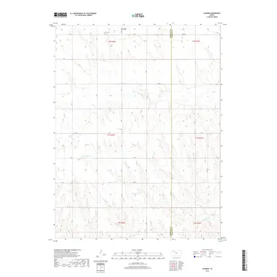
2018 Map of Lucerne
USGS Topo · Published 2018About this map
Lucerne sits in the northern reaches of this Sheridan County landscape, anchored by the Lucerne Cem just south of RD 110 N. The terrain is defined by a network of drainage systems that carve through the High Plains, including the winding path of Bow Cr and its southern branch, S Bow Cr. Further south, Antelope Cr and Storer Cr move across the township sections, illustrating the natural water patterns essential to this agricultural region. The map captures the interface of Sheridan and Graham counties, where a systematic grid of section roads like 115th Ave and V Rd provides access to the open countryside. This 2018 survey detail reflects the enduring rural character of the area, where watercourses like Foster Cr and Keys Cr dictate the local geography between vast stretches of farm and ranch land.
Find a feature on this map
30 named features on this map. Tap any name to fly to it.
Don’t see what you’re looking for? This feature index may not catch every label — zoom into the map to look around manually.
Map Details
Editions of this 2018 Lucerne Map
This is the sole edition of this map. No revisions or reprints were ever made.
Other maps of this area

1954 · Goodland
USGS Topo · 1:250,000

1956 · Goodland
USGS Topo · 1:250,000

1957 · Goodland
USGS Topo · 1:250,000
1978 · Clayton SW
USGS Topo · 1:24,000
1978 · Allison
USGS Topo · 1:24,000
1978 · Lenora West
USGS Topo · 1:24,000
1979 · Lucerne
USGS Topo · 1:24,000
1979 · Morland
USGS Topo · 1:24,000
1979 · Hoxie NE
USGS Topo · 1:24,000
1979 · Tasco
USGS Topo · 1:24,000