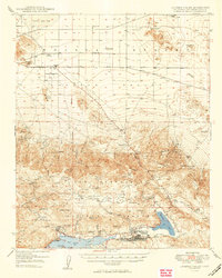
1949 Map of Lucerne Valley
USGS Topo · Published 1949About this map
Lucerne Valley is depicted here at a point of mid-century transition, where the arid flats of the Mojave Desert meet the high timber of the San Bernardino Mountains. The northern landscape is defined by the Lucerne Dry Lake and scattered outposts like the Box S Ranch, while the southern portion reveals a complex network of high-altitude valleys and mining districts. This 1946 topography preserves the era's reliance on remote springs such as Cushenbury Sprs and Rabbit Springs to sustain local ranching and settlement.
Find a feature on this map
60 named features on this map. Tap any name to fly to it.
Don’t see what you’re looking for? This feature index may not catch every label — zoom into the map to look around manually.
Map Details
Editions of this 1949 Lucerne Valley Map
2 editions found
Other maps of this area

1899 · Redlands
USGS Topo · 1:62,500

1901 · Southern California Sheet No. 1
USGS Topo · 1:250,000

1901 · Redlands
USGS Topo · 1:62,500

1902 · Deep Creek
USGS Topo · 1:62,500

1902 · San Gorgonio
USGS Topo · 1:125,000

1904 · Southern California Sheet No. 1
USGS Topo · 1:250,000

1932 · Barstow
USGS Topo · 1:125,000

1934 · Barstow
USGS Topo · 1:125,000

1947 · Lucerne Valley
USGS Topo · 1:62,500

1949 · Lucerne Valley
USGS Topo · 1:62,500