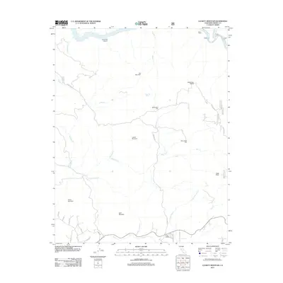
2012 Map of Luckett Mountain
USGS Topo · Published 2012About this map
Luckett Mountain and the surrounding high country of Fresno County are defined by a complex network of canyons and ridges carved by the Kings River and its numerous tributaries. This 2012 survey reveals a landscape largely shaped by its water sources and forest roads, including Coyote Springs Cr, Redoak Cr, and Sycamore Cr. While the terrain is dominated by peaks like Oat Mountain and Dalton Mountain, the map identifies specific locales of human activity such as Kellers Ranch in the north and the road intersection at Clingans Junction to the south. Notable flatlands and saddles, including White Deer Flat, White Deer Saddle, and Alex Jones Flat, suggest the historical use of more level ground within the varied elevation. The presence of Usfs RD 12s19 and Hopewell RD illustrates the continued importance of Forest Service infrastructure for accessing these remote foothills and mountain passes.
Find a feature on this map
36 named features on this map. Tap any name to fly to it.
Don’t see what you’re looking for? This feature index may not catch every label — zoom into the map to look around manually.
Map Details
Editions of this 2012 Luckett Mountain Map
This is the sole edition of this map. No revisions or reprints were ever made.
Other maps of this area
1921 · Squaw Valley
USGS Topo · 1:31,680
1922 · Trimmer
USGS Topo · 1:96,000
1924 · Citrus Cove
USGS Topo · 1:31,680
1924 · Dinuba
USGS Topo · 1:125,000
1942 · Watts Valley
USGS Topo · 1:62,500
1942 · Dunlap
USGS Topo · 1:62,500
1944 · Watts Valley
USGS Topo · 1:62,500
1944 · Dunlap
USGS Topo · 1:62,500
1948 · Fresno
USGS Topo · 1:250,000
1950 · Orange Cove North
USGS Topo · 1:24,000