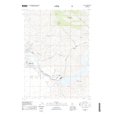
2020 Map of Lucky Peak
USGS Topo · Published 2020About this map
Boise City and the eastern reaches of the Boise Valley occupy the western edge of this 2020 landscape, where the urban footprint meets the rising foothills of the Boise National Forest. The map documents a complex interface of historic transportation routes and modern water management. The ancient path of the Oregon Trail is clearly delineated as it winds through the southern terrain, paralleled by a network of recreation paths like the Boise River Greenbelt. To the east, the topography climbs toward Lucky Peak and Shaw Mtn, punctuated by the significant waters of Lucky Peak Lake. The hydraulic engineering of the region is evident in the New York Canal and Penitentiary Canal, which draw from the Boise River to sustain the valley. Old settlement sites such as Barber are visible alongside specialized infrastructure like the Adelman Mine Trail and various gulches, including Lydle Gulch and Maynard Gulch, that carve through the high ground.
Find a feature on this map
62 named features on this map. Tap any name to fly to it.
Don’t see what you’re looking for? This feature index may not catch every label — zoom into the map to look around manually.
Map Details
Editions of this 2020 Lucky Peak Map
This is the sole edition of this map. No revisions or reprints were ever made.
Other maps of this area

1892 · Mountain Home
USGS Topo · 1:125,000

1892 · Boise
USGS Topo · 1:125,000

1892 · Bisuka
USGS Topo · 1:125,000

1893 · Mountain Home
USGS Topo · 1:125,000

1894 · Bisuka
USGS Topo · 1:125,000

1894 · Idaho Basin
USGS Topo · 1:125,000

1897 · Boise
USGS Topo · 1:125,000

1949 · Robie Creek
USGS Topo · 1:24,000

1954 · Boise South
USGS Topo · 1:24,000

1954 · Boise North
USGS Topo · 1:24,000