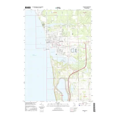
2017 Map of Ludington
USGS Topo · Published 2017About this map
Ludington sits at the vital junction where the Pere Marquette River and Lincoln River meet the eastern shore of Lake Michigan. This 2017 survey shows a landscape defined by its waterways, from the harbor at Pere Marquette Lake to the residential areas near Lincoln Lake. The map reveals a high concentration of local heritage sites, including Lakeview Cem near North Epworth and Pere Marquette Cem closer to the city center. South of the city, the narrow peninsula of Buttersville separates the lake from the river mouth, while smaller tributaries like Mosquito Cr and Saint Clair Cr drain the eastern hills. The presence of Mason County Airport and a grid of secondary roads like Piney Ridge Rd illustrate the modern development around this historic Lake Michigan port.
Find a feature on this map
78 named features on this map. Tap any name to fly to it.
Don’t see what you’re looking for? This feature index may not catch every label — zoom into the map to look around manually.
Map Details
Editions of this 2017 Ludington Map
This is the sole edition of this map. No revisions or reprints were ever made.
Other maps of this area

1931 · Manistee SE
USGS Topo · 1:31,680

1931 · Manistee SW
USGS Topo · 1:31,680

1932 · Ludington NE
USGS Topo · 1:31,680

1932 · Ludington SW
USGS Topo · 1:31,680

1932 · Ludington SE
USGS Topo · 1:31,680

1932 · Ludington
USGS Topo · 1:31,680

1954 · Milwaukee
USGS Topo · 1:250,000

1954 · Manitowoc
USGS Topo · 1:250,000

1958 · Manitowoc
USGS Topo · 1:250,000

1958 · Milwaukee
USGS Topo · 1:250,000
Featured Places
- Ludington, MI
- Pere Marquette Charter Township, MI
- Victory Township, MI
- Amber Township, MI
- Buttersville, MI