
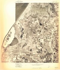
1932 Map of Ludington SW
USGS Topo · Published 1932About this map
The coastal village of Pentwater sits at the junction of Lake Michigan and the sheltered Pentwater Lake, serving as a vital focal point for maritime and rail activity in the early 1930s. The Pere Marquette railroad line terminates along the southern shore of the lake, underscoring the era's reliance on both shipping and rail transport. Inland, the landscape is defined by the winding Pentwater River and the rural school system, with nodes like Fairview Sch, Nickerson Sch, and Star Valley Sch serving the local farming and timber families. Further north, the recreation potential of the shoreline is evident at Bass Lake Park near Bass Lake, where the U S Highway No 31 corridor provides a primary north-south artery through the county. The map also records the boundary between Mason and Oceana Counties, marking the transition between these two prominent West Michigan regions.
Find a feature on this map
17 named features on this map. Tap any name to fly to it.
Don’t see what you’re looking for? This feature index may not catch every label — zoom into the map to look around manually.
Map Details
Editions of this 1932 Ludington SW Map
This is the sole edition of this map. No revisions or reprints were ever made.
Other maps of this area

1931 · Hart NW
USGS Topo · 1:31,680

1931 · Hart NE
USGS Topo · 1:31,680

1932 · Ludington NE
USGS Topo · 1:31,680

1932 · Ludington SE
USGS Topo · 1:31,680

1932 · Ludington
USGS Topo · 1:31,680

1954 · Milwaukee
USGS Topo · 1:250,000

1958 · Milwaukee
USGS Topo · 1:250,000

1959 · Ludington
USGS Topo · 1:62,500

1959 · Hart
USGS Topo · 1:62,500
1976 · Hart NW
USGS Topo · 1:24,000