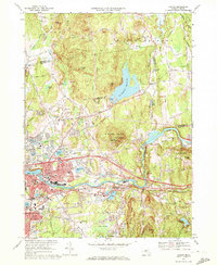
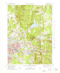
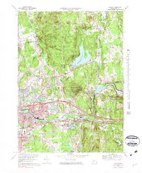
1969 Map of Ludlow
USGS Topo · Published 1972About this map
The Chicopee River carves a path through the southern industrial and residential corridor of this late-1960s landscape, separating Ludlow and Indian Orchard from North Wilbraham. The area's mid-century development is anchored by the Massachusetts Turnpike and Interchange 6, which spurred commercial growth like the local Shopping Center and a Drive-in Theater. Older settlement patterns remain visible in the scattered hamlets of Ludlow Center and Ludlow City, while the northern terrain is dominated by the sprawling Springfield Reservoir and its associated Filtration Plant. This survey reveals the transition of Hampden County from its river-mill roots toward suburban expansion, evidenced by numerous local schools like the Chapin St Sch and Veterans Park Sch. Prominent natural landmarks such as Minechoag Mountain and the Ludlow State Forest provide a wooded contrast to the rail lines of the Penn Central and Central Vermont that trace the river valley.
Find a feature on this map
83 named features on this map. Tap any name to fly to it.
Don’t see what you’re looking for? This feature index may not catch every label — zoom into the map to look around manually.
Map Details
Editions of this 1969 Ludlow Map
4 editions found

Other maps of this area

1885 · Northampton
USGS Topo · 1:62,500

1886 · Springfield
USGS Topo · 1:62,500

1886 · Northampton
USGS Topo · 1:62,500

1887 · Palmer
USGS Topo · 1:62,500

1887 · Belchertown
USGS Topo · 1:62,500

1889 · Springfield
USGS Topo · 1:62,500

1889 · Palmer
USGS Topo · 1:62,500

1890 · Belchertown
USGS Topo · 1:62,500

1891 · Northampton
USGS Topo · 1:62,500

1893 · Northampton
USGS Topo · 1:62,500