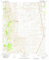
1982 Map of Luis Lopez
USGS Topo · Published 1982About this map
Mining operations and cattle ranching define the landscape of the Chupadera Mountains in the early 1980s. The eastern corridor is dominated by the Atchison Topeka and Santa Fe railroad line, which runs parallel to the settlements of Luis Lopez and San Antonio. This transportation artery connects the rural Rio Grande valley to larger markets, while the interior is marked by rugged canyons like Black Canyon and Nogal Canyon.
Find a feature on this map
33 named features on this map. Tap any name to fly to it.
Don’t see what you’re looking for? This feature index may not catch every label — zoom into the map to look around manually.
Map Details
Editions of this 1982 Luis Lopez Map
This is the sole edition of this map. No revisions or reprints were ever made.
Other maps of this area

1906 · Socorro
USGS Topo · 1:62,500

1916 · La Joya
USGS Topo · 1:125,000

1948 · San Antonio
USGS Topo · 1:62,500

1954 · Tularosa
USGS Topo · 1:250,000

1954 · Socorro
USGS Topo · 1:250,000

1958 · Socorro
USGS Topo · 1:250,000

1958 · Tularosa
USGS Topo · 1:250,000

1959 · Loma De Las Canas
USGS Topo · 1:24,000

1959 · Socorro
USGS Topo · 1:24,000

1959 · Magdalena
USGS Topo · 1:62,500