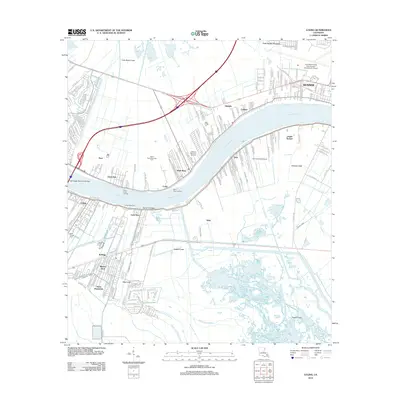
2012 Map of Luling
USGS Topo · Published 2012About this map
The Mississippi River carves a sharp path through this landscape, dividing riverfront communities like Destrehan and Saint Rose from southern settlements including Luling and Ama. This 2012 survey illustrates the heavy industrial and transportation infrastructure of the corridor, from the North Saint Rose Gas Field to the massive footprint of the Louis Armstrong New Orleans International Airport. Water management is central to the area's geography, evidenced by a dense network of man-made waterways such as the Sellers Canal, Dusuaua Canal, and Garland Canal. Local history is anchored by landmarks like the Saint Charles Cemetery and the Davis Crevasse, a site of significant flooding history near Lone Star. The map also captures the scale of the Hale Boggs Memorial Bridge, which serves as a vital artery connecting these historic river parishes while the landscape transitions into the wetlands of Bayou des Saules and Bayou Bois Piquant.
Find a feature on this map
42 named features on this map. Tap any name to fly to it.
Don’t see what you’re looking for? This feature index may not catch every label — zoom into the map to look around manually.
Map Details
Editions of this 2012 Luling Map
This is the sole edition of this map. No revisions or reprints were ever made.
Other maps of this area

1891 · Hahnville
USGS Topo · 1:62,500

1891 · Spanish Fort
USGS Topo · 1:62,500

1891 · New Orleans
USGS Topo · 1:62,500

1892 · Bonnet Carre
USGS Topo · 1:62,500

1932 · New Orleans NW
USGS Topo · 1:31,680

1932 · New Orleans SW
USGS Topo · 1:31,680

1932 · Hahnville NW
USGS Topo · 1:31,680

1932 · Hahnville SW
USGS Topo · 1:31,680

1932 · Hahnville NE
USGS Topo · 1:31,680

1935 · Laplace
USGS Topo · 1:31,680