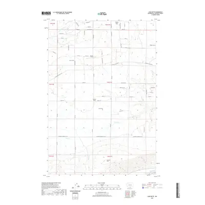
2020 Map of Luna Butte
USGS Topo · Published 2020About this map
Lake Umatilla and the Columbia River anchor the southern boundary of this high-plateau landscape in Klickitat County. The terrain rises sharply from the riverbanks into the Columbia Hills, giving way to the agricultural expanse of the Klickitat Valley. This 2020 record of the region captures the modern rural infrastructure, including private aviation sites like Aerostone Ranch Airport and Hillcrest Airport, which sit among a grid of long-established ranch roads.
Find a feature on this map
62 named features on this map. Tap any name to fly to it.
Don’t see what you’re looking for? This feature index may not catch every label — zoom into the map to look around manually.
Map Details
Editions of this 2020 Luna Butte Map
This is the sole edition of this map. No revisions or reprints were ever made.
Other maps of this area

1953 · The Dalles
USGS Topo · 1:250,000

1956 · The Dalles
USGS Topo · 1:250,000

1957 · The Dalles
USGS Topo · 1:250,000

1957 · Wasco
USGS Topo · 1:62,500

1957 · Goldendale
USGS Topo · 1:62,500

1957 · Wishram
USGS Topo · 1:62,500

1957 · Satus Pass
USGS Topo · 1:62,500

1971 · Quinton
USGS Topo · 1:24,000

1971 · Rufus
USGS Topo · 1:24,000
1977 · Biggs Junction
USGS Topo · 1:24,000